List of Iona place-names beginning with 'S'
Sauðey †
Kilfinichen & Kilvickeon (KKV), Iona (IOX)
Classification: Island
Grid reference: NM2440019253
Certainty: 1
Altitude: 6m
Elements: ON sauðr + ON ey
Translation: 'sheep island'
Description:
This name reflects the Old Norse place-name now known as Sòthaigh | Soa (q.v. for a full discussion of this name).
Sgeir a’ Mhountaineer
Kilfinichen & Kilvickeon (KKV), Iona (IOX)
Classification: Coastal, Relief
Grid reference: NM2984226238
Certainty: 1
Altitude: m
Elements: G sgeir + en A’ Mhountaineer +
Translation: 'skerry of the Mountaineer'
Sgeir a’ Mhountaineer
Kilfinichen & Kilvickeon (KKV), Iona (IOX)
Classification: Coastal, Relief
Grid reference: NM2902024478
Certainty: 1
Altitude: m
Elements: G sgeir + en A’ Mhountaineer
Translation: 'skerry of the Mountaineer'
Sgeir Aithne
Kilfinichen & Kilvickeon (KKV)
Classification: Coastal, Relief
Grid reference: NM2865423928
Certainty: 1
Altitude: m
Elements: G sgeir +
Translation: 'skerry of ?'
Sgeir an Òir
Kilfinichen & Kilvickeon (KKV)
Classification: Coastal, Relief
Grid reference: NM2595620672
Certainty: 1
Altitude: m
Elements: G sgeir + G an + G òr
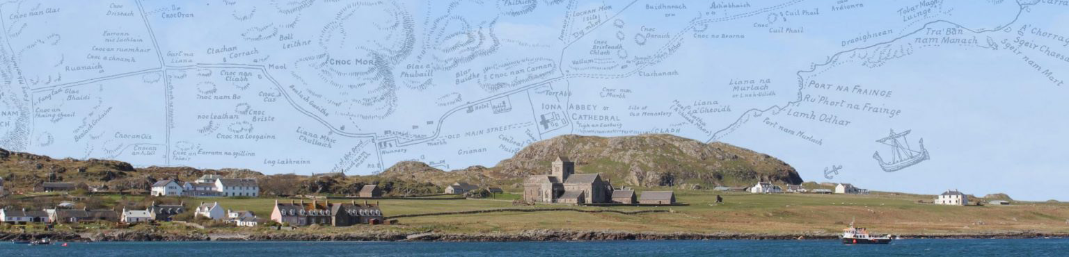
Sgeir Chaesar
Kilfinichen & Kilvickeon (KKV), Iona (IOX)
Classification: Coastal, Relief
Grid reference: NM2939225999
Certainty: 1
Altitude: m
Elements: G sgeir + pn Caesar
Translation: 'Caesar's skerry'
Sgeir Eighe
Kilfinichen & Kilvickeon (KKV)
Classification: Coastal, Relief
Grid reference:
Certainty: 1
Altitude: m
Elements: G sgeir + G eighe
Sgeir Fir Thiriodh
Kilfinichen & Kilvickeon (KKV), Iona (IOX)
Classification: Coastal, Relief
Grid reference: NM2582323726
Certainty: 1
Altitude: m
Elements: G sgeir + G fear + en Tiriodh
Translation: 'skerry of the Tiree-men'?
Sgeir Leathann
Kilfinichen & Kilvickeon (KKV)
Classification: Coastal, Relief
Grid reference: NM2637023915
Certainty: 1
Altitude: m
Elements: G sgeir + G leathann
Sgeir MhicCaluim
Kilfinichen & Kilvickeon (KKV)
Classification: Coastal, Relief
Grid reference:
Certainty: 1
Altitude: m
Elements: G sgeir + pn MacCaluim
Translation: ‘MacCaluim’s skerry’
Sgeir na Caoineig
Kilfinichen & Kilvickeon (KKV), Iona (IOX)
Classification: Coastal, Relief
Grid reference: NM2666423760
Certainty: 1
Altitude: m
Elements: G sgeir + G an + G caoineag
Translation: ‘skerry of the weeper’
Description:
A sea rock which forms part of the Machair coastline. The name was likely coined in reference to the sound of the wind at this particular spot. The relationship between landscape and sound is discussed by Bateman (2020, pp. 125-30) who cites several examples of the wind being described in Gaelic in terms of weeping, crying or moaning. These sounds may subsequently, as in this instance, become associated with supernatural beings, such as the caoineag, or caointeach (see MacKillop 2004 s.v. coineag and caointeach). The caoineag is variously described as a ‘Naiad who fortells the death of, and weeps for those slain in battle’ (Dwelly), a ‘wailing female’ (Morrison) or ‘a banshee’ (MacDougall 1910, pp. 214-15). Carmichael (CG2, p. 240) describes her as follows:
Unlike “nigheag,” “caoineag” cannot be approached nor questioned. She is seldom seen, but often heard in the hill, in the glen, and in the corrie, by the lake, by the stream, and by the water-fall. Her mourning and weeping cause much trepidation to night-farers, and much anxiety to parents whose sons are in the wars.
A story collected by MacDougall (1910, pp. 214-15) tells of how the caointeach was a banshee who followed the clans in the Rhinns of Islay, foretelling death by wailing outside the door of a sick man’s house.
Munro Fraser provides an alternative spelling of the name, Sgeir na Cuinneig, proposing instead G cuinneag ‘pail, milk-pail’ as the specific element, but there is no reason to assume that this analysis would be more accurate considering the appropriateness of the element caoineag outlined here.
Sgeir nam Mairt
Kilfinichen & Kilvickeon (KKV), Iona (IOX)
Classification: Coastal, Relief
Grid reference: NM2937725955
Certainty: 1
Altitude: m
Elements: G sgeir + G an + G mart
Translation: ‘skerry of the cows’
Description:
A coastal rock which forms part of Tràigh Bàn at the northern end of Iona. As noted by Trenholme (1909, p. 75), the name seems to refer to the rock having been used as a landing place for cattle before the boat pier at Baile Mòr was built. Mairi MacArthur (1990 2nd ed, p. 195) notes that ‘in early times the cattle may have been swum over the mile of water at Bunessan market times but, by the late nineteenth century, they were always ferried in open boats.’ Malcolm Ferguson recounted the ferrying process, noting that ‘two or three cows or up to six stirks could be transported at once but, [...] a bull was usually made to swim behind the boat’. He described one instance of the cows being put on the boat in 1893: ‘Two strong active men stand up to their middle in the water; the one grasps the animal by the forelegs, the other by the hindlegs and back to back pull with the hands and give a sudden shove with their shoulders, and the animal is whummelled heels over head into the boat’ (cited in MacArthur 1990 2nd ed, pp. 195-6).
The passage from Sgeir nam Mairt was the starting point of a drovers’ route which took the cattle from Iona to Glasgow before it became standard to ship them by boat. John MacGillvray described the arduous land-route journey:
The Iona folk complain that they have difficulty getting away their sheep and cattle. But is there not a fair in Bunessan in May and August and the Dunara to take sheep and lambs to Glasgow? That is not the same as the wandering people used to have to do. I was but a boy when I went with my uncle Donald to Falkirk. We were driving a herd of black cattle … We got them through Glen Mòr but that was only the start of our problems. We ferried them from Grasspoint to Kerrera and over the strait to Lorne. We took shelter for the night at Taynuilt and were up on the move again with the blackbird…
(translation in MacArthur 1990 2nd ed, p. 194. Original Gaelic available via NLS Coll A. MacDonald 1938 p. 31).
According to Trenholme, this rock also played a central role in the Christmas Eve massacre of 986, in local tradition believed to have taken place at Tràigh Bàn. Skene, citing tradition, is our first written source to describe the slaughter of the monks here (see entry for Tràigh Bàn), but he does not mention Sgeir nam Mairt. Trenholme (1909, p. 75) includes a more detailed description of the event, stating that ‘The story of a slaughter of monks there [Tràigh Bàn] is still current in the island, and they are said to have been killed on the dark steep-sided rock [Sgeir nam Mairt] that bounds this particular stretch of sand on the north’. It seems plausible that there has been some confusion here owing to the similarity of the name with Port nam Mairtir ‘port of the martyrs’, for which see entry.
Sgeir Ruadh
Kilfinichen & Kilvickeon (KKV), Iona (IOX)
Classification: Coastal, Relief
Grid reference: NM2763722240
Certainty: 1
Altitude: m
Elements: G sgeir + G ruadh
Translation: ‘red skerry’
Description:
A sea rock on the south-east coast line, described in the OS Name Books as ‘a rock on the E coast of “Iona,” situate immediately E. of “Druim Dhughaill”, and about 1/8 of a mile S.W. of “Eilean Carrach,”’.
According to Dugald MacArthur (TAD ID 84012 part 2, 18:10) Sgeir Ruadh, along with Eilean Mòr and Eilean Carrach, are notable for being Ross of Mull granite intrusions, geologically different from the rest of Iona. The name almost certainly refers to the reddish colour of the rock, distinctive from the Iona coastline (see image).
Sgeir Uilleim
Kilfinichen & Kilvickeon (KKV)
Classification: Coastal, Relief
Grid reference: NM2635923905
Certainty: 1
Altitude: m
Elements: G sgeir + pn Uilleam
Sgeirean Bhun an Uisge
Kilfinichen & Kilvickeon (KKV)
Classification: Coastal, Relief
Grid reference: NM2662823841
Certainty: 1
Altitude: m
Elements: G sgeir + en *Bun an Uisge
Sgùrr an Fhithich
Kilfinichen & Kilvickeon (KKV), Iona (IOX)
Classification: Relief
Grid reference: NM2838524581
Certainty: 1
Altitude: 35m
Elements: G sgùrr + G an + G fitheach
Translation: 'peak of the raven'
Description:
This feature is on the high ground to the west of the abbey area, and south of, and overlooking, Lochan Mòr. Ravens are regularly seen on Iona, and occasionally nest on the island (see Raven’s Crag). It is described in the OS Name Books (OS1/2/37/5) as 'A small portion of precipitous rock on the flat ground about a eighth of a mile west of the Cathedral. Meaning “Cliff of the Raven”.'
Sgùrr Beag
Kilfinichen & Kilvickeon (KKV), Iona (IOX)
Classification: Relief
Grid reference: NM2773322954
Certainty: 1
Altitude: 27m
Elements: G sgùrr + G beag
Translation: ‘Small sharp-pointed hill’
Description:
This rocky feature is named as one of a contrasting pair, the other being Sgùrr Mòr (q.v.). which rises somewhat higher than Sgùrr Beag, about 200 m. to the west of it.
Sgùrr Mòr
Kilfinichen & Kilvickeon (KKV), Iona (IOX)
Classification: Relief
Grid reference: NM2733222776
Certainty: 1
Altitude: 57m
Elements: G sgùrr + G mòr
Translation: ‘Big sharp-pointed hill’
Description:
This is named as one of a contrasting pair, the other being Sgùrr Beag (q.v.), which is somewhat lower than Sgùrr Mòr and is about 200 m. to the east of it.
Shian
Kilfinichen & Kilvickeon (KKV)
Classification: Settlement
Grid reference: NM2706023584
Certainty: 1
Altitude: 14m
Elements: en (An) Sìthean
Sìthean Beag
Kilfinichen & Kilvickeon (KKV)
Classification: Relief
Grid reference: NM2714923804
Certainty: 1
Altitude: 11m
Elements: G sìthean + G beag
Sìthean Mòr
Kilfinichen & Kilvickeon (KKV), Iona (IOX)
Classification: Antiquity, Relief
Grid reference: NM2721623712
Certainty: 1
Altitude: 12m
Elements: G sìthean + G mòr
Sìthean Mòr na h-Àird
Kilfinichen & Kilvickeon (KKV)
Classification: Relief
Grid reference: NM2687521858
Certainty: 1
Altitude: 15m
Elements: G sìthean + G mòr + en An Àird
Sliabh Meadhanach
Kilfinichen & Kilvickeon (KKV), Iona (IOX)
Classification: Other
Grid reference: NM2722224749
Certainty: 1
Altitude: 41m
Elements: G sliabh + G meadhanach
Translation: ‘The middle hill or upland grazing’
Description:
This refers to a stretch of land which will have been common upland grazing in the past. It should be understood as the ‘middle’ in the sense of lying between Dùn Ì and surrounding hill-grazing to the north and the hilly ground to the south-west called Sliabh Siar (q.v.), and also perhaps as lying in the ‘middle’ between the coastal plains on the west and east sides of the island.
Sliabh Siar
Kilfinichen & Kilvickeon (KKV), Iona (IOX)
Classification: Other
Grid reference: NM2694722637
Certainty: 1
Altitude: 60m
Elements: G sliabh + G siar
Translation: ‘The western hill or upland grazing’
Description:
This name is used both to describe the common grazing for one part of the island, but the English name shown on the 19th century Censuses indicates that it also could stand for the whole of the West End of the island (in contrast to the East End, Ceann an t-Sear). It is perhaps worth remarking in the context of this name that a line drawn from Sliabh Siar to the opposite end of the island, more or less marking what we might call its ‘axis’, runs 32 degrees east of north, and so 58 degrees north of east, meaning that the axis is much closer to north-south than it is to east-west. Nevertheless the local perception is that the southernmost part of the island is the ‘west’ end, and the northernmost part is the ‘east’ end.
Sligineach
Kilfinichen & Kilvickeon (KKV), Iona (IOX)
Classification: Settlement
Grid reference: NM2814423407
Certainty: 1
Altitude: 6m
Elements: G sligneach
Translation: ‘having a shell, shelly, abounding in shells’
Description:
Sligineach is the name given to a stretch of coastline which is characterised by jagged rocky platforms and expanses of white shelly sand, and then later the settlement of houses in that area, lying to the south of the main harbour. Extending 1.7 km from Tràigh nan Siolag in the south as far as Baile Mòr in the north, this ‘shelly sand’ presumably explains the name, perhaps together with the presence in the rocky areas of various shellfish, including common rock barnacle (Semibalanus balandoides), Montagu’s stellate barnacle (Chthalamus montagui), limpets (Patella sp.), rough periwinkle (Littornia saxatilis) and dog whelks (Nucella lapillus) (Data taken from the report of a Marine Environmental Appraisal of Sligineach undertaken for British Telecommunications PLC in 2021, in advance of laying fibre-optic cable at the site).
The form of the name derives from the Gaelic adjective sligneach ‘having a shell, shelly’, based on the noun slige ‘a shell’. The name on Iona contains a ‘epenthetic vowel’, between the g and the n (think of how Glaswegians pronounce film as ‘filuhm’), and that vowel has over time come to be written as part of the name. The form of the name in our earliest source, a song by Angus Lamont from the first half of the 19th century, suggests that originally it may have had a definite article, i.e., *An t-Sligneach, ‘the shelly place?’, but that is not attested in the modern forms, so we have not included it in the head-name. Note, however Port Beag na Sliginich contains the article.
The OS Name Book does not reflect on the meaning of the settlement-name, but records it as referring to: ‘A district comprising six small crofts in the island of Iona half a mile south of the village of Baile Mòr. Property of His Grace the Duke of Argyll’ (OS 1/2/37/38). These crofts in time gave way to an expansion of housing on the island, after Am Baile Mòr, most of them built in the 20th century.
Sloc a’ Ghàrraidh Ghil
Kilfinichen & Kilvickeon (KKV), Iona (IOX)
Classification: Relief
Grid reference: NM2762822536
Certainty: 1
Altitude: 14m
Elements: G sloc + en Gàrradh Geal
Sloc an Luirin
Kilfinichen & Kilvickeon (KKV)
Classification: Relief
Grid reference: NM2710121958
Certainty: 1
Altitude: 4m
Elements: G sloc + G an + G *luidhrean
Translation: ?‘gully / hollow of the little chimney’
Sloc Bò Mhàrtainn
Kilfinichen & Kilvickeon (KKV), Iona (IOX)
Classification: Relief
Grid reference: NM2591222731
Certainty: 2
Altitude: 13m
Elements: G sloc + G bò + pn Màrtainn
Translation: ‘hollow of Martin’s cow’
Sloc Bò Phàidein
Kilfinichen & Kilvickeon (KKV)
Classification: Relief
Grid reference: NM2669021608
Certainty: 1
Altitude: 8m
Elements: G sloc + G bò + pn Pàidean
Translation: ‘Pat’s cow's gully / hollow’
Sloc Ceann an Amair
Kilfinichen & Kilvickeon (KKV), Iona (IOX)
Classification: Relief
Grid reference: NM2594522720
Certainty: 1
Altitude: 18m
Elements: G sloc + en *Ceann an Amair
Sloc Dubh
Kilfinichen & Kilvickeon (KKV)
Classification: Relief
Grid reference: NM2709021983
Certainty: 1
Altitude: 6m
Elements: G sloc + G dubh
Sloc Dùn Mhanannain
Kilfinichen & Kilvickeon (KKV)
Classification: Relief
Grid reference: NM2650225008
Certainty: 1
Altitude: 1m
Elements: G sloc + en Dùn Mhanannain
Sloc Ghillebhranain
Kilfinichen & Kilvickeon (KKV)
Classification: Relief
Grid reference: NM2705923209
Certainty: 1
Altitude: 33m
Elements: G sloc + pn Gillebhranain
Translation: ‘hollow of Gillebhranain’
Sloc na Bò Duibhe
Kilfinichen & Kilvickeon (KKV)
Classification: Relief
Grid reference: NM2749525589
Certainty: 1
Altitude: 6m
Elements: G sloc + G an + G bò + G dubh
Sloc na Caillich-oidhche
Kilfinichen & Kilvickeon (KKV)
Classification: Relief
Grid reference: NM2854325243
Certainty: 1
Altitude: 51m
Elements: G sloc + G an + G cailleach-oidhche
Translation: 'gully of the owl'
Sloc na Ceàrdaich
Kilfinichen & Kilvickeon (KKV)
Classification: Relief
Grid reference: NM2775022734
Certainty: 1
Altitude: 13m
Elements: G sloc + G an + G ceàrdach
Sloc nam Ball
Kilfinichen & Kilvickeon (KKV)
Classification: Relief
Grid reference: NM2714625267
Certainty: 1
Altitude: 5m
Elements: G sloc + G an + G ball
Sloc nam Maighdeag
Kilfinichen & Kilvickeon (KKV)
Classification: Relief
Grid reference: NM27902286
Certainty: 1
Altitude: 3m
Elements: G sloc + G an + G maighdeag
Sloc nam Muc
Kilfinichen & Kilvickeon (KKV)
Classification: Relief
Grid reference: NM2777822677
Certainty: 1
Altitude: 7m
Elements: G sloc + G an + G muc
Translation: ‘hollow of the pigs’
Sloc nan Lunn
Kilfinichen & Kilvickeon (KKV)
Classification: Relief
Grid reference: NM2798223175
Certainty: 1
Altitude: 5m
Elements: G sloc + G an + G lunn
Sloc Srath Mugain
Kilfinichen & Kilvickeon (KKV)
Classification: Relief
Grid reference: NM2675825191
Certainty: 1
Altitude: 1m
Elements: G sloc +
Slochd nan Biast †
Kilfinichen & Kilvickeon (KKV), Iona (IOX)
Classification: Relief
Grid reference:
Certainty: 1
Altitude: m
Elements: G sloc + G an + G biast
Sòthaigh | Soa
Kilfinichen & Kilvickeon (KKV), Iona (IOX)
Classification: Island
Grid reference: NM2440019233
Certainty: 1
Altitude: 5m
Elements: en *Sauðey
Sràid nam Marbh | Street of the Dead
Kilfinichen & Kilvickeon (KKV), Iona (IOX)
Classification: Antiquity, Ecclesiastical, Other
Grid reference: NM2861124483
Certainty: 1
Altitude: 21m
Elements: G sràid + G an + G marbh
Description:
Sràid nam Marbh or ‘the street of the dead’ is a name that first appears in the nineteenth century. It might be thought that its existence was noted a little before that after his visit in 1772 Pennant observed: Advance from hence [i.e. from the nunnery] along a broad paved way, which is continued in a line from the nunnery to the cathedral: another branches from it to the Bay of Martyrs: and a third narrower than the others, points towards the hills (Pennant 1774, 283). This account of a ‘broad paved way’ running from the Bay of Martyrs, past the nunnery, and continuing to the ‘cathedral’, the abbey church, may seem to refer to what would later be called Sràid nam Marbh. That may be true for its southern reaches, between Port nam Mairtir and the nunnery, but is probably not true for the section running north from the nunnery. That is more likely to refer to the Main Street which ran in a straight line from Teampall Rònain | St Ronan’s Church beside the nunnery to the southern side of the Abbey Church. The name Sràid nam Marbh, or here Street of the Dead, is explained, along with a more detailed description of its course, in the OS Name Book (OS1/2/37/32):
Street of the Dead. This street is traditionally said to have run from An Eala at Port mam[sic] Mairtir through the fields, and trending westward of the ruins of the Nunnery passed the present School and Established Church onward to Reilig Oran. It thus ran for a certain distance parallel to Main Street but was used solely for carrying the dead to the graveyard. Hence the name.
It is interesting that the OS Name Book gives the name in English rather than Gaelic. It is followed in this by the OS 6 inch 1st ed map (1881). The map shows ‘Street of the Dead (site of)’ running north from Port nam Mairtir (during this section it is not given a name) as far as the west side of the nunnery. There it makes a slight right-hand turn, and is named on the map, continuing past the nunnery (on its west side) and past the school, the manse and the Victorian parish church (passing them all on the east side). Thereafter it is not marked on the map. Its course on this map runs parallel to and west of the Main Street which runs from the north side of St Ronan’s, which is labelled ‘chapel (in ruins)’. When it reaches Macleans’s Cross the original Main Street seems to have disappeared by 1881, and its course is marked ‘Site of Main Street’, as it continues to the south transept of the Abbey church marked only as a pair of dotted lines. The actual road in 1881 bent to the left at Maclean’s Cross, and then to the right to run past the St Columba Hotel and past the west side of Rèilig Odhráin (Reilig Orain), much as the tarmac road does today.
By the time of the second edition of the OS 6 inch map (1900), it may be that knowledge of the Street of the Dead had expanded, as a single dotted line (which did not appear on the 1st ed map) runs from near the northern end of Street of the Dead for a short distance, only to disappear under St Columba’s Hotel, again parallel to and west of Main Street. At this point Street of the Dead (if that is what the dotted line represents) is heading directly towards Rèilig Odhrain (which is now called St Oran’s Chap.).
There is a map of the ‘improved’ landscape of Iona made in 1769 by William Douglas, now in the Archives of Inveraray Castle, which shows a rather different layout of roads in Am Baile Mòr and the area of the Abbey (see image). It shows no road from Port nam Mairtir to the nunnery, but shows a road running in a perfectly straight line from a point south-west of the Nunnery northwards towards Rèilig Odhrain. However, instead of continuing northwards to Rèilig Odhrain, this road makes a right-turn towards the north-east and meets another road (labelled Street, which appears to be the OS map’s Main Street) which runs towards the south transept of the Abbey church, but then veers slightly towards the east towards the gate of a field marked ‘Green Pasture’, east of the Abbey buildings. A third road on this map runs south-east from Maclean’s Cross towards the eastern part of the village. The roads on this map, with their straight lines and sharp corners probably record what was then a fairly recent development of the landscape. This means that we should not use this map to record the route of the Street of the Dead.
The very name Street of the Dead, together with accounts of dead bodies being brought for burial on Iona being landed at Port nam Mairtir, suggests that the road must have headed towards a burial ground. We know that the burial ground for Hebridean chiefs and important people, as well as for Iona folk in recent centuries, was at Rèilig Odhrain. It would be strange if the Street of the Dead did not originally lead there. This would imply that rather than turning north-east, as indicated on the 1769 plan, the Street of the Dead continued northwards, parallel to Main Street, to Rèilig Odhrain. It is remarkable also that another section of road runs northwards from Rèilig Odhrain to the western end of the Abbey church and the area of St Columba’s supposed tomb-shrine. This section has been archaeologically excavated and its stones are still visible. It is likely that this section of road was originally constructed in the seventh or eighth century (Campbell and Maldonado 2020, 22). Its presence and importance, marked by this very early use of slabs and boulders for road construction in what has been compared to their use for Roman roads, also urge us to accept that the Street of the Dead originally ran from the Nunnery, under what is now St Columba Hotel. and to Rèilig Odhráin, and must be distinguished from the much later Main Street shown on the 1769 map. Campbell and Maldonado have also shown that this proposed medieval route (as distinct from the Main Street) was lined by several crosses, mostly early medieval, indicating that this was the Street of the Dead, the route along which people brought their dead for burial over the course of several centuries.
Srath Dubh
Kilfinichen & Kilvickeon (KKV)
Classification: Relief
Grid reference: NM2846625485
Certainty: 1
Altitude: 16m
Elements: G srath + G dubh
Sròn Iolaire
Kilfinichen & Kilvickeon (KKV)
Classification: Relief
Grid reference: NM2718123407
Certainty: 1
Altitude: 23m
Elements: G sròn + G iolair
Translation: 'eagle's nose'
Sruth a’ Mhuilinn
Kilfinichen & Kilvickeon (KKV), Iona (IOX)
Classification: Water
Grid reference: NM2893924470
Certainty: 1
Altitude: 1m
Elements: G sruth + G an + G muileann
Translation: 'stream/current of the mill'
St Adomnán’s Cross
Kilfinichen & Kilvickeon (KKV)
Classification: Antiquity, Ecclesiastical
Grid reference: NM2873224255
Certainty: 1
Altitude: 4m
Elements: G crois + pn Adhamhnan (St)
St Columba Hotel
Kilfinichen & Kilvickeon (KKV)
Classification: Settlement
Grid reference: NM2853224354
Certainty: 1
Altitude: 20m
Elements: pn Calum Cille ~ Columba (St) + SSE hotel
St Columba's House
Kilfinichen & Kilvickeon (KKV)
Classification: Settlement
Grid reference: NM2868724251
Certainty: 1
Altitude: 6m
St Martin’s Caves
Kilfinichen & Kilvickeon (KKV), Iona (IOX)
Classification: Other
Grid reference: NM2587122749
Certainty: 1
Altitude: 7m
Elements: pn Màrtainn ~ Martin (St) + SSE cave
Translation: 'St Martin's caves'
Description:
A series of rocky passages and caves which form part of the coastal end of Sloc Ceann an Amair at the south-western shoreline of the island. It is only accessible at low tide. The OS maps mark the feature as a cave and do not provide any names for relevant features here. The Ritchies give the Gaelic name for the gully, Sloc Ceann an Amair, but they equate this name with the caves.
There are a couple of problems with this name. Firstly, although the Ritchies equate Sloc Ceann an Amair with St Martin’s Caves, they should properly be viewed as two separate features; the former referring to the gully and the latter the series of passages and caves located at the end of the gully (also see separate entry for Sloc Ceann an Amair). Secondly, this raises the question regarding the existence of a Gaelic form of the name St Martin’s Caves. The name has been translated into Gaelic on multiple occasions: Uamh Mhartainn (the form given on The Iona Community’s map of Iona) or Uamhan Naoimh Mhàrtainn (NTS ‘Explore Iona’), but there is little evidence to suggest that such names were ever used locally. Because of this, we have not supplied a Gaelic form as part of the headname.
All evidence seems to point towards Sloc Ceann an Amair being the Gaelic name used to describe both the gully and passages/caves before the name St Martin’s Caves was coined, likely in English.
What about the name St Martin’s Caves? The available name forms, and the fact that it seems to have been originally coined in English, seem to indicate a rather late date. As noted, the OS maps do not give a name for the caves and Reeves makes no mention of it. On the other hand, we do have a nearby name in Gaelic which does mention the personal name Màrtainn ~ Martin, Eilean Maol-Mhàrtainn, located directly south of St Martin’s Caves. Eilean Maol-Mhàrtainn is likely a much earlier name, possibly medieval, and may contain the personal name which would have been rendered in the early Middle Ages as Máel Martainn ‘follower of St Martin’ (see entry for Eilean Maol-Mhàrtainn). If this interpretation is correct, it is a rather strange coincidence to find a potentially medieval feature named after a Mael Martainn and a much later (English) name containing a dedication to St Martin. It therefore seems likely that these names are indeed connected. The name St Martin’s Caves may in fact be the result of a misunderstanding of the name Eilean Maol-Mhàrtainn. Although this name does not contain a direct dedication to the saint Martin (although arguably the personal name Mael Martainn is indirectly a dedication to the saint), an English-speaker would easily spot the personal name Martin and might have assumed that this was a reference to the saint, particularly considering the well-known St Martin’s Cross near the Abbey entrance.
Some of the passages which form part of St Martin’s Caves have openings to the landward side, which give the appearance of windows. This has led to the nickname The Galleries, known by islanders and visitors from around the 1920s onward. A visitor called Stuart Steele was taken to Iona as a child in 1934 and he returned every summer (except in war time and the pandemic); he recalls that Stanley Service, another regular visitor, ‘led us to The Galleries, a popular name for the St Martin’s Caves which are still quite difficult to find’. On later visits he and his wife liked to go there, but they did find the thick seaweed hard to walk over safely (Memories of Iona, p.58, printed in 2019 for The Iona Heritage Centre).
St Ronan’s Bay
Kilfinichen & Kilvickeon (KKV)
Classification: Coastal
Grid reference: NM2866124085
Certainty: 1
Altitude: 1m
Description:
This English name seems to be at once a translation of the Gaelic name Port Rònain, and at the same time a description of a slighter wider landscape feature. Several Gaelic names in port have English equivalents employing bay, where the English name seems to describe a slightly larger and different aspect, and we have thus given them separate headnames. For a discussion of the name and its meaning, see Port Rònain.
St Ronan’s Street
Kilfinichen & Kilvickeon (KKV)
Classification: Other
Grid reference: NM2857124105
Certainty: 1
Altitude: 6m
Elements: pn Rònan (St) + SSE street
St. Columbus’s Well †
Kilfinichen & Kilvickeon (KKV), Iona (IOX)
Classification: Antiquity, Water
Grid reference: NM2872824549
Certainty: 3
Altitude: 16m
Elements: pn Calum Cille ~ Columba (St) + SSE well
Description:
This is the only mention of a well dedicated to St Columba that has come to our attention. It is not clear from Boswell’s record who informed him of the dedication of the well, nor where it was. Whether the supposed dedication was a traditional one, or a recently invented one to inspire or amuse visitors, is impossible to say. Boswell was interested, however, in the fact that the water is conveyed in leaden pipes, and comments on its outflow into the well: ‘All the I could observe was that at the well the water came out of a flat freestone with a springing motion, as if conducted to the orifice by a pipe’
Stac a’ Chorr
Kilfinichen & Kilvickeon (KKV), Iona (IOX)
Classification: Relief
Grid reference: NM2596224521
Certainty: 1
Altitude: 1m
Elements: G stac + en (A’) Chorr(-Eilean)
Stac an Aoinidh
Kilfinichen & Kilvickeon (KKV)
Classification: Relief
Grid reference: NM2522122629
Certainty: 1
Altitude: 2m
Elements: G stac + G an + G aoineadh
Stac Liath
Kilfinichen & Kilvickeon (KKV)
Classification: Relief
Grid reference: NM2609823893
Certainty: 1
Altitude: m
Elements: G stac + G liath
Stac MhicLaomainn
Kilfinichen & Kilvickeon (KKV), Iona (IOX)
Classification: Relief
Grid reference: NM2910624819
Certainty: 1
Altitude: 1m
Elements: G stac + pn MacLaomainn
Translation: ‘MacLaomainn’s (MacLamont) stack’
Stac MhicMhurchaidh
Kilfinichen & Kilvickeon (KKV)
Classification: Relief
Grid reference: NM2408726178
Certainty: 1
Altitude: 6m
Elements: G stac + pn MacMhurchaidh
Translation: ‘MacMhurchaidh’s stack’
Staonaig
Kilfinichen & Kilvickeon (KKV), Iona (IOX)
Classification: Other
Grid reference: NM2642222343
Certainty: 1
Altitude: 38m
Elements: en *Stein-vík
Stein-vík †
Kilfinichen & Kilvickeon (KKV), Iona (IOX)
Classification: Settlement
Grid reference: NM2639622410
Certainty: 2
Altitude: 44m
Elements: ON steinn + ON vík
Translation: ?'Rocky islets' cove'