List of Iona place-names beginning with 'R'
Raven's Crag
Kilfinichen & Kilvickeon (KKV), Iona (IOX)
Classification: Coastal, Relief
Grid reference: NM255220
Certainty: 1
Altitude: 6m
Translation: 'raven's crag'
Description:
This name seems to be unknown outside the rock-climbing community, but among climbers it is a well-known rock with a number of routes of varying difficulty ascending different parts of it. The UK Climbing website (https://www.ukclimbing.com/) lists and describes several routes, and has generated a list of interesting names (as climbers often do) for the different routes. There are three sections of Raven’s Crag: The Main Wall, The Pulpit and The Altar. On The Main Wall the routes include: Welly Route, Allah Be Praised, Yabbadabbadoo, Mr Muscle, God is Dead, Crusade, Sola Temple, Waco, Cul Dreimne, The Bantry Boat, Smoking the Toad, Prodigy, Mental Torment, Quartzness. On The Pulpit the routes are curiously and appropriately ecclesiastical: Parable, Scripture, Fire and Brimstone, Communion Wine. On the section called The Altar the routes are: The Incredible Dr Sex, Blood Eagle, Smoke Yourself Thin.
According to the same website, ‘Ravens ocasionally [sic] nest here (None present 2024) If ravens are nesting at the crag avoid climbing between March - June.’ For further evidence of ravens in Iona’s toponymy, see Sgùrr an Fhithich.
For a sustained enquiry into the naming of features and routes in the climbing community see Sheila M. Young, ‘The Eternal Ascent: an exploratory treatise on mountain route names’, The Journal of Scottish Name Studies 10 (2016), 137-205.
Rèidh-Eilean
Kilfinichen & Kilvickeon (KKV), Iona (IOX)
Classification: Island
Grid reference: NM2444426269
Certainty: 1
Altitude: 6m
Elements: G rèidh + G eilean
Translation: ‘flat island’
Description:
A flat, rocky island located roughly two kilometres north-west of Iona. It lies next to Stac MhicMhurchaidh. The OS Name Books describe it as ‘A rocky island situated two miles west of the north west end of Iona.’
Dugald MacArthur notes that this island, along with several other islands surrounding Iona, was used to put stock on and that they ‘go with Calva’ (TAD ID 84012 part 1, 44:45). He is also aware of the earlier name-forms, discussed below, and states that the local pronunciation of the name is ‘Rèidhling’.
It is worth noting that G rèidh can also have the meaning ‘clear of obstruction, safe’, which would be a conceivably appropriate description for an island which ships regularly sailed past. However, considering the relatively flat, smooth characteristics of Rèidh-Eilean, especially in comparison with Stac MhicMhurchaidh, it seems likely that the name refers to its flat nature, thus meaning ‘Flat island’. Adjectives referring to colour and size often precede the noun they qualify, as is the case here; this phenomenon is visible in several other Iona place-names (also see in other parts of Scotland e.g. PNF 5, p. 169).
Admiralty Chart no. 2617 in addition to naming the island in question, gives the name of a submerged rock located north-east of Rèidh-Eilean; Bo an Reidh eilean, in standardised Gaelic *Bodha an Rèidh-Eilean ‘Submerged rock of (the) Rèidh-Eilean’. This name is not recorded in any other sources and is therefore discussed here rather than listed under its own entry. The rock is clearly visible on modern satellite images. It is worth noting that the existing name Rèidh-Eilean is here given with the definite article. The addition of the definite article when incorporating an existing name into a new name is attested elsewhere in an Iona context (for example see Bruthach na Ceapaich, Cnocan na Buidhnich, Port a’ Ghoirtein Bhig).
The island is mentioned in a song by James Campbell (Seamas MacPhàraig), partially recited by Peter MacInnes:
‘Tha mi seo an Demerara
Fada thall air cùl na grèine
Ach nam faighinn as mo dhèidh i
Sheòlainns’ i gu cùrsa Rèidh Eilean.’
I am here in Demerara,
far away beyond the sunset,
but if I could get it behind me
I would sail on a course for Rèidh Eilean.
(transcription by Mairi MacArthur 1990, pp. 294-5. For recording see TAD ID101623)
Rèidh-Eilean and the nearby island Stac MhicMhurchaidh are mentioned in various ways in our early written sources and maps. It is first mentioned by Dean Monro (1549 [1884], p. 34) who refers to what must be Rèidh-Eilean as Ellan Reringe. As noted by Sharpe (2012, p. 220), this is presumably merged with Stac MhicMhurchaidh. Monro describes it as ‘ane profitable ile of wild fowls eggis and for fisching, perteining to Colmkill’. A similar form, perhaps based on Monro’s account, can be found in Blaeu’s 1654 Atlas. His map form only includes Rering, but the text accompanying the maps gives Eilean Rering. It is, however, worth noting that something is clearly amiss here – the size of the island on the map is vastly out of proportion compared to Iona. It is also difficult to interpret what the settlement indicated by Blaeu refers to (see image), perhaps raising some uncertainty regarding the identification of Rering as Rèidh-Eilean.
Nevertheless, it seems plausible that these early forms ultimately reflect the same underlying name, particularly considering the local pronunciation provided by Dugald MacArthur (‘Rèidhling’), along with the pronunciation implied in the poem above, which essentially reflects what is recorded in our early sources, substituting r for l. It should also be noted that his understanding is that these early forms refer to Rèidh-Eilean. The replacement of the l with r may be the result of dissimilation.
It is noteworthy that John Monipennie’s 1612 text (1820, p. 180), based on Buchanan’s translation of Monro, seems to give a completely different name; Bernira. He writes: ‘Next unto it is the Isle of Women [Eilean nam Ban], then Rudana [Eilean Annraidh]; neere unto it Bernira, and from that Skennia [Inch Kenneth], halfe a mile distant from the Mule [Mull]’, listing it in the same place as Rering in other texts based on Monro. If it does indeed refer to Rèidh-Eilean, this form is difficult to explain; variants of Rering are consistently given in subsequent Monro manuscripts and in Buchanan (therein Reringa), so it is difficult to ascertain the origins of the form provided by Monipennie. An original *Bernera would undoubtedly represent a well-attested Old Norse island-name with ON ey ‘island’, and possibly ON björn ‘bear’. If the form recorded by Monipennie does accurately represent a medieval place-name, it would add to the list of island-names coined in Norse which surround Iona (also see Eilean Chalbha, Eilean Musimul, Soa).
Rèilig Odhrain
Kilfinichen & Kilvickeon (KKV), Iona (IOX)
Classification: Antiquity, Ecclesiastical
Grid reference: NM2858424441
Certainty: 1
Altitude: 21m
Elements: G rèilig + pn Odhran ~ Oran (St)
Translation: 'cemetery/burial-place of (St) Odhran'
Royal Street †
Kilfinichen & Kilvickeon (KKV), Iona (IOX)
Classification: Other
Grid reference: NM2857124105
Certainty: 1
Altitude: 6m
Elements: SSE royal + SSE street
Translation: Royal Street
Description:
This name appears to be a mistake. It enjoyed a brief flurry of existence in the nineteenth century, but there is no evidence that it was ever used on the island itself. Its first appearance in 1811 is an account by visitors who simply seem to have got it wrong, and this account was followed later by other accounts by and for visitors. The OS surveyors who made enquiries on Iona about the name discovered it was a mistake, a misrepresentation of the name St Ronan’s Street. The OS Name Book says this of St Ronan’s Street (OS1/2/37/31):
A short street which is supposed to have run from Main Street to the beach at St. Ronan’s Bay. In the Imperial Gazetteer of Scotland it is called “Royal Street”, but this is a mistake. No vestige of it remains.
The street ran SSE from Main Street, where MacLean’s Cross stood, to the back of what is now the Argyll Hotel and the shore. It is shown as St Ronan’s Street in Gothic script (therefore as an antiquity) on OS 6 inch 1st edn. It also seems to be shown, though not named, on the Douglas 1769 map, although in this case it does not extend all the way to the shore.
Ruamhar Bàn
Kilfinichen & Kilvickeon (KKV), Iona (IOX)
Classification: Other
Grid reference: NM2775722822
Certainty: 2
Altitude: 15m
Elements: G ruamhar + G bàn
Translation: '(the) white digging'
Description:
This name was collected by Mairi MacArthur. In her thesis, she notes of this place: ‘Ruamhar Ban (the white dig). May refer to the sandy soil. Traces of lazybeds still visible, past the waterfall at Sandeels Bay.’ (MacArthur 1989 vol. 2, p. 114) Ruamhar ‘digging, delving’, is quite an unusual Gaelic word for a generic, and its precise significance is uncertain. We know of one other instance , Ruamhar Fhearchair in Kincardine Parish (Ross and Cromarty, NH466907) where it refers to a bend in the Black Water; the OS Name Books translated it as ‘Farquhar's Delving’ (the authority, interestingly, was the local gamekeeper: OS1/28/18/54). However, there are other instances of it being used as the modifying element.
Ruanaich
Kilfinichen & Kilvickeon (KKV), Iona (IOX)
Classification: Settlement
Grid reference: NM2766423417
Certainty: 1
Altitude: 20m
Elements: G ruain + G -ach
Rubha a’ Bheòil Mhòir
Kilfinichen & Kilvickeon (KKV), Iona (IOX)
Classification: Coastal, Relief
Grid reference: NM2895126267
Certainty: 1
Altitude: m
Elements: G rubha + en (Am) Beul Mòr
Translation: '(the) point of the big inlet'
Rubha a’ Chosgarnaich
Kilfinichen & Kilvickeon (KKV), Iona (IOX)
Classification: Coastal, Relief
Grid reference: NM2885924319
Certainty: 1
Altitude: 1m
Elements: G rubha + G an + G cosgarrach
Translation: 'point of the kite'
Rubha an Èisg Mhòir
Kilfinichen & Kilvickeon (KKV)
Classification: Coastal, Relief
Grid reference: NM2599822943
Certainty: 1
Altitude: 1m
Elements: G rubha + G an + G iasg + G mòr
Translation: '(the) point of the big fish'
Rubha na Carraig Gèire
Kilfinichen & Kilvickeon (KKV), Iona (IOX)
Classification: Coastal, Relief
Grid reference: NM2661221490
Certainty: 1
Altitude: 5m
Elements: G rubha + G an + G carraig + G geur
Translation: 'point of the sharp rock'
Rubha na h-Àird
Kilfinichen & Kilvickeon (KKV), Iona (IOX)
Classification: Coastal, Relief
Grid reference: NM2907424593
Certainty: 1
Altitude: m
Elements: G rubha + en (An) Àird
Translation: 'point of An Àird'
Rubha na Sligeanaich
Kilfinichen & Kilvickeon (KKV)
Classification: Coastal, Relief
Grid reference: NM2831523467
Certainty: 1
Altitude: 1m
Elements: G rubha + en (An) t-Sligeanach
Translation: 'point of (An t-)Sligeanach'
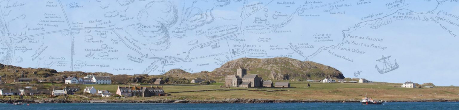
Rubha Phort na Fraing
Kilfinichen & Kilvickeon (KKV), Iona (IOX)
Classification: Coastal, Relief
Grid reference: NM2916925203
Certainty: 1
Altitude: 1m
Elements: G rubha + en Port na Fraing
Translation: '(the) point of Port na Fraing'
Rubha Phort nam Mairtir
Kilfinichen & Kilvickeon (KKV), Iona (IOX)
Classification: Coastal, Relief
Grid reference: NM2850223777
Certainty: 1
Altitude: 1m
Elements: G rubha + en Port nam Mairtir
Translation: '(the) point of Port nam Mairtir'