List of Iona place-names beginning with 'L'
L’on a chuspar †
Kilfinichen & Kilvickeon (KKV), Iona (IOX)
Classification: Water
Grid reference: NM2859324527
Certainty: 2
Altitude: 24m
Elements: G lòn + G an + G cuspair
Description:
This is an alternative name for the Lochan Mòr, and appears first in the account of 1771. Gordon’s reference to the name (and the supposed monastic archery area) is clearly dependent on the 1771 account, and thus not an additional source of information. It may be that both the name and the image of monks firing bows and arrows were the invention of an enthusiastic tour guide. Alternatively, might this be connected to an earlier established pattern of setting up archery practice targets near parish churches? The 1424 Statue of James I states that:
all men prepare themselves to be archers from when they are twelve years of age. And that in each £10 worth of land there be made bowmarks, and especially beside parish churches, where men on holy days may come and shoot at least three times and have practice of archery (The Records of the Parliaments of Scotland).
Also compare this with Lòn a’ Chuspair on Skye, ‘a part of the Ashaig common grazings above the graveyard. According to local tradition, this area was once used for archery practice by a local family, the MacInneses, who also taught archery’ (King with Scammell 2015, 20).
The name in its 1771 spelling is meaningless, but a reconstructed *Lòn a’ Chuspair might mean here ‘pond/marsh of the target’ (suggesting archery therefore), but cuspair has a range of meanings including ‘subject, object, lover, objective, purpose’. It is ultimately a loan-word from Latin cuspis ‘point, blade, spear, trident, sting (of a scorpion)’ (See Dwelly and DIL s.v. cuspóir). Whatever the origin of the name in the eighteenth century, the idea that the monks might have practised archery here is, in any case, a little far-fetched.
Lac a Chutar †
Kilfinichen & Kilvickeon (KKV), Iona (IOX)
Classification: Other
Grid reference: NM2857924235
Certainty: 1
Altitude: 10m
Elements: G leac + G an + G cunntair
Translation: ?'stone of the reckoner'
Lag an Dòbhrain
Kilfinichen & Kilvickeon (KKV)
Classification: Relief
Grid reference: NM2879325707
Certainty: 2
Altitude: 15m
Elements: G lag + G an + G dòbhran
Translation: 'hollow of the otter'
Lag Beul Mòr
Kilfinichen & Kilvickeon (KKV)
Classification: Relief
Grid reference: NM2589722523
Certainty: 1
Altitude: 20m
Elements: G lag + en (Am) Beul Mòr
Translation: 'hollow of (Am) Beul Mòr'
Lag Labhrainn
Kilfinichen & Kilvickeon (KKV)
Classification: Relief
Grid reference: NM2838223882
Certainty: 1
Altitude: 6m
Elements: G lag + pn Labhrann
Translation: 'Labhrann's (Lawrence's) hollow'
Lag nan Gìogan
Kilfinichen & Kilvickeon (KKV), Iona (IOX)
Classification: Relief
Grid reference: NM2739923663
Certainty: 2
Altitude: 14m
Elements: G lag + G an + G gìogan
Translation: 'hollow of the thistles'
Lag Odhar
Kilfinichen & Kilvickeon (KKV)
Classification: Relief
Grid reference: NM2639021818
Certainty: 1
Altitude: 11m
Elements: G lag + G odhar
Translation: 'dun-coloured hollow'
Lagandorain
Kilfinichen & Kilvickeon (KKV)
Classification: Settlement
Grid reference: NM2882625712
Certainty: 1
Altitude: 16m
Elements: en Lag an Dòbhrain
Translation: This adapts an existing name of a landscape feature: see entry for Lag an Dòbhrain
Lagnagigean
Kilfinichen & Kilvickeon (KKV)
Classification: Settlement
Grid reference: NM2740723674
Certainty: 1
Altitude: 14m
Elements: en Lag nan gìogan
Translation: This adapts an existing name of a landscape feature: see entry for Lag nan gìogan
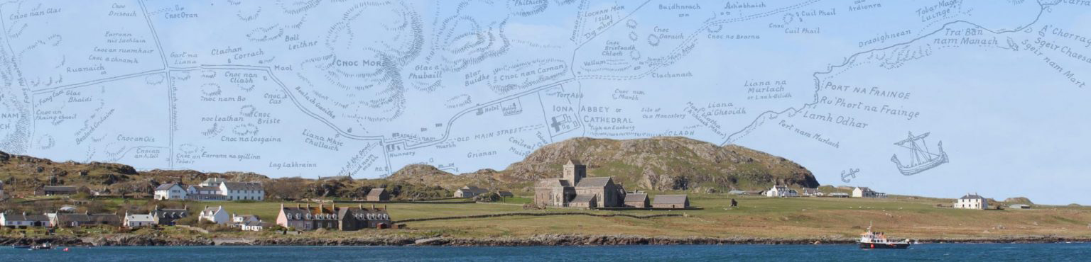
Làmh Odhar
Kilfinichen & Kilvickeon (KKV)
Classification: Coastal
Grid reference: NM2914625129
Certainty: 1
Altitude: 2m
Elements: G làmh + G odhar
Translation: 'dun-coloured hand'
Làraichean
Kilfinichen & Kilvickeon (KKV), Iona (IOX)
Classification: Antiquity, Settlement
Grid reference: NM2607621850
Certainty: 1
Altitude: 20m
Elements: G làrach
Translation: '(the) ruins'
Lathullt
Kilfinichen & Kilvickeon (KKV)
Classification: Relief
Grid reference: NM2730623950
Certainty: 1
Altitude: 16m
Elements: G leth + G allt
Translation: ?'half cliff'
Leabaidh nan Cearc
Kilfinichen & Kilvickeon (KKV)
Classification: Other
Grid reference: NM2838224068
Certainty: 1
Altitude: 22m
Elements: G leabaidh + G an + G cearc
Translation: 'bed of the chickens'
Leac
Kilfinichen & Kilvickeon (KKV)
Classification: Other
Grid reference: NM2727925313
Certainty: 1
Altitude: 5m
Elements: G leac
Translation: 'flag-stone/tombstone'
Leac Dhubh Ìdhe †
Kilfinichen & Kilvickeon (KKV), Iona (IOX)
Classification: Antiquity, Ecclesiastical
Grid reference: NM2865324511
Certainty: 1
Altitude: 19m
Translation: ?'black stone of Iona'
Leacach
Kilfinichen & Kilvickeon (KKV), Iona (IOX)
Classification: Other
Grid reference: NM2791823093
Certainty: 1
Altitude: 10m
Elements: G leac + G -ach
Translation: 'place of flag-stones/tombstones'
Leacht
Kilfinichen & Kilvickeon (KKV), Iona (IOX)
Classification: Antiquity, Ecclesiastical, Relief
Grid reference: NM289247
Certainty: 2
Altitude: 8m
Elements: G leac or G leachd
Translation: ?'stone slab' or 'burial monument'
Description:
We face several problems with this name. It appears only once in the record prior to the twenty-first century, and that is on Reeves’ 1857 map, very close to, and a short distance south of, Cladh an Dìseirt. Reeves does not discuss the name or the object in the text of his work, so we cannot tell what kind of an object the name Leacht refers to.
Most of the names on Reeves’ map are of coastal or relief features, and in most cases the name is simply written beside the feature being named. Relief features are drawn with tapering lines showing slopes and implying summits, thus allowing a free-floating name to be pinned to a particular location. The names of islands, bays and promontories are placed beside those coastal features as drawn on the map. The map does not name any individual modern (i.e. nineteenth-century) settlements or buildings (though the name Village is shown in the area of Am Baile Mòr), presumably because the map is intended to shed light on the medieval landscape of Iona – the map appears, after all, in Reeves’ The Life of St Columba. This map’s antiquarian interest is also reflected in the naming of medieval objects in the landscape, and sometimes the drawing of them on the map. Thus the abbey and church, Eaclus Mor, are named beside a simply drawn plan of the complex. Reilig Odhrain, Cill Ma Neachdain, Teach an Epscop and Cladh an Diseart are also each shown beside a small square, presumably representing the remains of square structures at those sites. But Leacht is shown beside a small circle. Does this mean that Reeves saw it as a circular object? Is the circle a simplified plan of the object, or is it merely a ‘dot’ marking the position of Leacht without any implications for its shape? In favour of the former it is worth noting that Reeves uses the same small circle to locate Cobhain Cuildich which is actually a circular feature in the landscape; in favour of the latter is the fact that Reeves uses the same small circle mark to locate Torr Abb, which is not a noticeably circular feature. This being the case, we cannot infer anything about what kind of object Leacht was from the circular mark on the map.
It is very likely, however, that Leacht was some kind of antiquity, or at least that it was seen that way by Reeves given the features which his map generally names. In that case we are left with two possible interpretations of the name. The first of these is Gaelic leachd (Old Gaelic lecht, modern Irish leacht), which is a loan-word from Latin lectus ‘a bed’. In Gaelic it was used to refer to a grave or tomb, or some kind of burial monument. Its range of meaning seems to have extended to other kinds of features, however, including ritual monuments at religious sites which are not obviously burials at all. Laghta Columbkille (‘Colum Cille’s leachd’), for example, on Inishmurray on the west coast of Ireland, is a large solid drystone structure about 1.5 m square, and rising to almost a metre in height, topped with broad slabs of stone with an early medieval carved cross standing slotted into the top of it. There is no reason to see this as a burial (let alone the burial-place of Colum Cille!). It is one of a series of such monuments around the island which were all points in processional ritual landscape. In 1886 it was described, in fact, as ‘an altar’ (Jerry O’Sullivan and Tomás Ó Carragáin 2008, 195-99).
The second possible explanation of the name Leacht lies in the Gaelic word leac ‘a slab, flat stone, flagstone’ (Old Gaelic lecc, with the same meaning). This might sometimes be a gravestone, but that it not intrinsic to its meaning. Its origin lies in Proto-Celtic likkā ‘flat stone’, and it has no connection at all to the word leachd discussed above, even though either of them might be used to refer to some kind of slabby stone object.
Adding to the confusion is that both leac and leachd are pronounced in the same way in Gaelic, with a final /xk/ - i.e. a voiceless velar fricative followed by a voiceless velar plosive. This is true of leac in dialect areas of Scotland where pre-aspiration before /k/ is used, and Iona lies in an area where such pre-aspiration is used. It is therefore impossible to say from the written form of the name whether Reeves’ Leacht represents G leachd or G leac. In fact it may be that Reeves himself had no idea that there were two such distinct words. It is significant that in his discussion of another place-name on his map, Liochd laithrichean, which he standardizes as leacht laithreachan, he translates the name as ‘flag of the ruins’, clearly thinking the name contains leac ‘flagstone’ (Reeves, 1857, 429). Dwelly also seems to imagine that leac and leachd are the same word, for in his dictionary s.v. leachd he says ‘see leac’; and under leac he defines the word as ‘flag, slab, flat stone. 2. Tomb-stone’, suggesting that he has wrongly conflated the two distinct words under one heading.
Given this confusion of leachd and leac in Gaelic, Reeves’ written form Leacht cannot help us decide whether this was a stone slab or a burial/ritual monument, a leac or a leachd. There are no remains of either type of monument at the site listed in the Canmore database, so whatever Reeves had noted there seems to have disappeared. It may be, of course, that there was nothing to see there even in 1857, when Reeves made his map; he may have simply acquired information from a local person about the site and whatever monument used to be there.
It might be thought that Reeves’ Leacht was an alternative name for A’ Chlach Mhòr, a rock nearby. But A’ Chlach Mhòr, sometimes called ‘St Columba’s Table’, is a granite boulder about 100m NW of Cladh an Diseirt, while Reeves shows Leacht some distance to the south. The referent of the name, and what it means, must remain unresolved for the present.
Liana a’ Gheòidh
Kilfinichen & Kilvickeon (KKV), Iona (IOX)
Classification: Field
Grid reference: NM2899624932
Certainty: 1
Altitude: 9m
Elements: G liana + G an + G gèadh
Translation: 'plain/meadow/corn-field of the goose'
Liana an Tairbh
Kilfinichen & Kilvickeon (KKV)
Classification: Field
Grid reference: NM2669921991
Certainty: 1
Altitude: 42m
Elements: G liana + G an + G tarbh
Translation: 'plain/meadow/corn-field of the bull'
Liana Chalbha
Kilfinichen & Kilvickeon (KKV), Iona (IOX)
Classification: Field
Grid reference: NM2779425441
Certainty: 1
Altitude: 16m
Elements: G liana + en Calbha
Translation: ‘plain/meadow/corn-field of Calbha’
Description:
A stretch of land located south-west of Calva croft.
The specific element has been transferred from Eilean Chalbha or the croft of Calva. In the context of the feature referring to a meadow, the latter may be more likely. Also see Dùn Chalbha for further discussion. Dugald MacArthur (TAD ID 84465 15:15) notes that there is a very large number of lazy beds in this area.
Liana MhicChullaich
Kilfinichen & Kilvickeon (KKV)
Classification: Field
Grid reference: NM2835323979
Certainty: 1
Altitude: 14m
Elements: G liana + pn MacCullach
Translation: 'MacCulloch's plain/meadow/corn-field'
Liana Mhòr
Kilfinichen & Kilvickeon (KKV)
Classification: Field
Grid reference: NM2880024361
Certainty: 1
Altitude: 4m
Elements: G liana + G mòr
Translation: 'large plain/meadow/corn-field'
Liana na h-Àird
Kilfinichen & Kilvickeon (KKV)
Classification: Field
Grid reference: NM2892324621
Certainty: 1
Altitude: 4m
Elements: G liana + en (An) Àird
Translation: 'plain/meadow/corn-field of (An) Àird'
Liana na h-Uilidh
Kilfinichen & Kilvickeon (KKV)
Classification: Field
Grid reference: NM2900625085
Certainty: 1
Altitude: 10m
Elements: G liana + G an + G ulaidh
Translation: 'plain/meadow/corn-field of the treasure'
Liana nam Mùrlach
Kilfinichen & Kilvickeon (KKV)
Classification: Field
Grid reference: NM2900625085
Certainty: 1
Altitude: 10m
Elements: G liana + G an + G mùrlach
Translation: 'plain/meadow/corn-field of the kingfishers'
Liath-Eilean
Kilfinichen & Kilvickeon (KKV)
Classification: Island
Grid reference: NM2980224638
Certainty: 1
Altitude: m
Elements: G liath + G eilean
Translation: 'grey island'
Liochd Làraichean
Kilfinichen & Kilvickeon (KKV)
Classification: Other
Grid reference: NM2604221686
Certainty: 1
Altitude: 2m
Elements: G liochd + en Làraichean
Translation: 'flag-stone of Làraichean'
Liochd Màiri Buidhe
Kilfinichen & Kilvickeon (KKV)
Classification: Other
Grid reference: NM2555421911
Certainty: 1
Altitude: 4m
Elements: G liochd + pn Màiri Buidhe
Translation: 'Màiri Buidhe's (yellow Mary) flag-stone'
Liochd Port a’ Churaich
Kilfinichen & Kilvickeon (KKV), Iona (IOX)
Classification: Other
Grid reference: NM2639121614
Certainty: 1
Altitude: 3m
Elements: G liochd + en Port a’ Churaich
Translation: 'flag-stone of Port a’ Churaich'
Loch Staonaig
Kilfinichen & Kilvickeon (KKV)
Classification: Water
Grid reference: NM2655622644
Certainty: 1
Altitude: 47m
Elements: G loch + en Staonaig
Translation: 'loch of Staonaig'
Lochan a’ Bhàrr Ruaidh
Kilfinichen & Kilvickeon (KKV), Iona (IOX)
Classification: Water
Grid reference:
Certainty: 4
Altitude: m
Elements: G lochan + en *A’ Bhàrr Ruaidh
Translation: 'little loch of A’ Bhàrr Ruaidh'
Lochan a’ Mhanaich
Kilfinichen & Kilvickeon (KKV), Iona (IOX)
Classification: Water
Grid reference:
Certainty: 4
Altitude: m
Elements: G lochan + G an + G manach
Translation: 'little loch of the monk'
Lochan Dubh
Kilfinichen & Kilvickeon (KKV)
Classification: Water
Grid reference: NM26582417
Certainty: 2
Altitude: 6m
Elements: G lochan + G dubh
Translation: 'black/dark little loch'
Lochan Liana nan Curracagan
Kilfinichen & Kilvickeon (KKV)
Classification: Water
Grid reference: NM2780924812
Certainty: 1
Altitude: 41m
Elements: G lochan + en *Liana nan Curracagan
Translation: 'little loch of Liana nan Curracagan'
Lochan Mhic an Aoig
Kilfinichen & Kilvickeon (KKV)
Classification: Water
Grid reference: NM2678823176
Certainty: 1
Altitude: 14m
Elements: G lochan + pn Mac an Aoig
Translation: 'little loch of Mac an Aoig'
Lochan Mòr
Kilfinichen & Kilvickeon (KKV)
Classification: Water
Grid reference: NM2845324763
Certainty: 1
Altitude: 26m
Elements: G lochan + G mòr
Translation: 'large little loch'
Lochan na Croise
Kilfinichen & Kilvickeon (KKV)
Classification: Water
Grid reference:
Certainty: 4
Altitude: m
Elements: G lochan + G an + G crois
Translation: 'little loch of the cross'
Lòn na Poit-Dhubh
Kilfinichen & Kilvickeon (KKV)
Classification: Vegetation
Grid reference: NM2790024797
Certainty: 1
Altitude: 36m
Elements: G lòn + G an + G poit-dhubh
Translation: 'meadow/marsh of the still'
Lòn nam Manach
Kilfinichen & Kilvickeon (KKV), Iona (IOX)
Classification: Vegetation
Grid reference: NM2660724023
Certainty: 1
Altitude: 1m
Elements: G lòn + G an + G manach
Translation: 'meadow/marsh/pool of the monks'
Description:
G lòn has a range of meanings, and it is not clear which one is most appropriate for Lòn nam Manach. Dwelly offers the following rather varied meanings: ‘meadow, lawn, small brook especially with marshy banks, marsh, morass, pond, lakelet, water, mud’. It may be that G lòn in this meaning is ultimately a loan-word from ON lón ‘pool, tranquil part of a river or lake, inlet, sea-loch, lagoon’ (Cox 2002, 337; Cleasby-Vigfussen s.v. lón), implying that the watery sense of the Gaelic word originally predominated, but that it extended to include not only marshy ground but also meadows and lawns (perhaps originally low-lying meadows close to water).
An alternative possibility is that G lòn, with its wide range of meanings, represents the coming together of two distinct words, one ‘watery’ loan-word from ON lón as suggested above, and one, as suggested by McBain (1896) a Gaelic word deriving, via OG loth ‘mud, mire, marsh’, from *lut-no (related to Latin lutum ‘mud, mire’).
In the case of Lòn nam Manach, it is hard to know whether the ‘pool’ sense, or the ‘meadow/marsh’ sense is the origin. Reeves shows the name Loan nam Manach engraved on a bay, on the sea itself but immediately adjacent to the land, leaving the referent of the name ambiguous. But the Ritchie map shows Lon nam Manach as a strip of low-lying land, close to the sea at the west side of the Machair. The Ritchies may be right, and the name applied to this strip of land; or the Ritchie map may have misinterpreted Reeves’ map which (possibly) applied the name to a part of the bay.
Losaid
Kilfinichen & Kilvickeon (KKV), Iona (IOX)
Classification: Field
Grid reference: NM2875324771
Certainty: 1
Altitude: 22m
Elements: G losaid
Translation: '(the) kneading-trough' or '(the) plate or dish (for holding potatoes)'