List of Iona place-names beginning with 'G'
Gàrradh Dhiarmaid
Kilfinichen & Kilvickeon (KKV)
Classification: Other
Grid reference: NM2867325245
Certainty: 1
Altitude: 30m
Elements: G gàrradh + pn Diarmad
Translation: 'Diarmad's garden/enclosure'
Gàrradh Dubh Staonaig
Kilfinichen & Kilvickeon (KKV)
Classification: Other
Grid reference: NM2675322477
Certainty: 1
Altitude: 52m
Elements: G gàrradh + G dubh + en Staonaig
Translation: 'black/dark garden/enclosure of Staonaig'
Gàrradh Eachainn Òig
Kilfinichen & Kilvickeon (KKV)
Classification: Other
Grid reference: NM2653422066
Certainty: 1
Altitude: 30m
Elements: G gàrradh + pn Eachann Òig
Translation: 'Eachann Òig's garden/enclosure'
Gàrradh Geal
Kilfinichen & Kilvickeon (KKV)
Classification: Other
Grid reference: NM2766622569
Certainty: 1
Altitude: 15m
Elements: G gàrradh + G geal
Translation: 'white garden/enclosure or cave'
Gàrradh Marsaili
Kilfinichen & Kilvickeon (KKV)
Classification: Other
Grid reference: NM2852924178
Certainty: 1
Altitude: 12m
Elements: G gàrradh + pn Marsaili
Translation: 'Marsaili's garden/enclosure'
Gàrradh Mòr
Kilfinichen & Kilvickeon (KKV)
Classification: Other
Grid reference: NM2730823328
Certainty: 1
Altitude: 25m
Elements: G gàrradh + G mòr
Translation: 'large garden/enclosure'
Gàrradh Sgolban
Kilfinichen & Kilvickeon (KKV)
Classification: Other
Grid reference: NM2835225071
Certainty: 1
Altitude: 61m
Elements: G gàrradh + G sgolb
Translation: 'garden/enclosure of the wattles or thorns'
Gart na Liana
Kilfinichen & Kilvickeon (KKV)
Classification: Field
Grid reference: NM2777323651
Certainty: 1
Altitude: 18m
Elements: G gart + G an + G liana
Translation: 'enclosure of the plain/meadow/corn-field'
Geodha Cnoc a’ Chròtha
Kilfinichen & Kilvickeon (KKV)
Classification: Coastal
Grid reference: NM2729325353
Certainty: 1
Altitude: 4m
Elements: G geodha + en Cnoc a’ Chròtha
Translation: 'cove/creek of Cnoc a’ Chròtha'
Geodha Ruaraidh
Kilfinichen & Kilvickeon (KKV)
Classification: Coastal
Grid reference: NM2778425819
Certainty: 1
Altitude: m
Elements: G geodha + pn Ruaraidh
Translation: 'cove/creek of Ruaraidh'
Glac a’ Choilich
Kilfinichen & Kilvickeon (KKV), Iona (IOX)
Classification: Relief
Grid reference: NM2642921937
Certainty: 1
Altitude: 14m
Elements: G glac + G an + G coileach
Translation: 'defile/hollow of the cockerel'
Glac a’ Phùbaill
Kilfinichen & Kilvickeon (KKV), Iona (IOX)
Classification: Relief
Grid reference: NM2833424238
Certainty: 1
Altitude: 41m
Elements: G glac + G an + G pùball
Translation: 'defile/hollow of the tent'
Glac Bhaldi
Kilfinichen & Kilvickeon (KKV)
Classification: Relief
Grid reference: NM2772223357
Certainty: 1
Altitude: 23m
Elements: G glac + pn Baldi
Translation: 'defile/hollow of Baldi'
Glas-Eilean
Kilfinichen & Kilvickeon (KKV), Iona (IOX)
Classification: Coastal
Grid reference: NM2806523079
Certainty: 1
Altitude: 1m
Elements: G glas + G eilean
Translation: 'grey/green island'
Gleann an Teampaill
Kilfinichen & Kilvickeon (KKV)
Classification: Relief
Grid reference: NM2748024152
Certainty: 1
Altitude: 17m
Elements: G gleann + G an + G teampall
Translation: 'valley/glen of the temple/church'
Description:
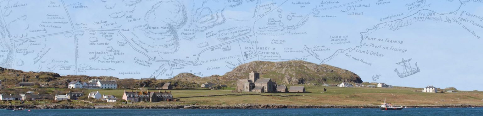
This small glen lies between Cnoc Mòr and the Machair. It seems to have gone by two names, Gleann an Teampaill and Gleann Cùl Bhuirg (qv), though they are not always equally represented in sources (see below for details). The ambiguity persisted into the twentieth century as shown by oral recordings. Peter MacInnes in 1986 (see here 00:45) said that this area ‘is known as Gleann an Teampuill’. On the other hand, Dugald MacArthur in 1966 (see here, part 1 31:50) gave Gleann Cùl Bhuirg as ‘the usual name’, stating that Gleann an Teampuill ‘is another name, there’s supposed to be a temple buried there at one time’.
The generic element in both names for this feature is G gleann, m. ‘valley, opening between two heights’ (Dwelly s.v. gleann). This is a common element in Scottish place-names, but this is the only Iona place named with this element. The lack of names with gleann in our area must partially be a natural result of the topography of the island. This can be contrasted with place-names containing the element G bealach which are exceedingly common. The specific in Gleann Cùl Bhuirg is an existing name, referring to the farm of Culbhuirg which is located at the south-western opening of the valley.
Its two names (Gleann Cùl Bhuirg and Gleann an Teampaill) arguably describe the two ‘destinations’ for anyone traversing the glen: the farm of Culbhuirg (or the feature it was named for, Cùl Bhuirg) to the south-west and Teampall Rònain to the north-east. Although the RCAHMS survey of Iona thought that Douglas’s 1769 Map of Iona showed this route blocked off at the Cùl Bhuirg end by a loch, this interpretation seems uncertain (RCAHMS 1982, 35). While the glen itself does not immediately give access to Teampall Rònain, following a line from it through Glac a’ Phubaill takes you there. Indeed, this is the line followed by the stone boundary dyke constructed in the 1780s and 1790s: ‘running from the Machair shore west of Cùlbhuirg, through Gleann an Teampuill, over the north side of Cnoc Mòr to behind where the Church of Scotland Manse stands today’ (MacArthur 2002, 36), the manse being more or less adjacent to Teampall Rònain.
As such, the teampall in the name undoubtedly represents the church of Teampall Rònain, which is in any case the only church on the island known to have consistently employed that element (though it is found in Gaelic forms for St Odhran’s Chapel as well). For a discussion of the element, see under Teampall Rònain. It is possible that the name Gleann an Teampaill could imply some other sort of relationship, for instance, the proceeds of the lands of this glen might have at some stage supported that church.
It is William Reeves who seems to have first made the undoubtedly mistaken suggestion that this name is somehow connected to the events recorded in the Annals of Ulster for 1204:
‘Glen of the Church,’ the name of a remarkable valley commencing in the middle of the island, at the back of Cnocmor, with a level floor, and walled in on either side with a well-defined range of hill, inclining towards the south-west, and opening out on the northern part of the Machar. The name has long been a subject of local speculation as to its origin; but possibly the occurrence recorded in the Irish Annals, at 1203 [recte 1204], may both account for the name and, with it, for the total absence of all ecclesiastical remains in the place. ‘A monastery was erected by Cellach, without any legal right, and in despite of the family of Hy, in the middle of Cro-Hy, and did much damage to the town. The clergy of the north of Ireland passed over into Hy, and, in accordance with the law of the Church, they pulled down the aforesaid Monastery’ (412).
This speculation was followed by the Royal Society of Antiquaries of Ireland in 1899, and McNeill 1920. It is unwarranted. As noted above, the reference an teampall can be otherwise explained, and there is no reason to think, with Reeves, that this is where AU’s cró Ia (rendered Cro-Hy by Reeves ‘the enclosure of Iona’: the word cró has many potential meanings however: see https://dil.ie/13021 ). Much more likely from the description is that it was somewhere in the vicinity of the cathedral. An important detail here is that the annal entry says that a ‘monastery’ (mainistir) was erected. It is very unlikely that such a complex would acquire the term teampall, used for churches.
OS maps only record Gleann Cùl Bhurg, but we can actually trace the process of standardisation to find an explanation as to why the name ‘Gleann an Teampuill’ has not been included on any OS maps. The OS Name Books originally included both names, with a different set of informants for each name, but at some stage, presumably before the 1st edn maps were made, Gleann an Teampuill and the second set of informants (who presumably gave this name form) were crossed out. The name Gleann Cùl Bhuirg seems to have been used locally alongside Gleann an Teampaill: D. Munro Fraser records both place-names, stating that Gleann an Teampuill is also called Gleann Culbhuirg and as noted Dugald MacArthur similarly gives both names (see above). Additionally, we should note that the OS 6 inch 2nd edn map records the name An Teampull which does not appear anywhere else. This looks to be a misinterpretation of the original (crossed out) OSNB entry, or perhaps a slightly botched attempt to record both names.
If the referent of Gleann Cùl Bhuirg is, as is likely, the farm of Culbhuirg, then without doubt Gleann an Teampaill is the earlier name. Note that we have standardised the spelling of the earlier forms teampull, gen. sg. teampuill to the modern convention of teampall, gen. sg. teampaill.
Gleann Cùl Bhuirg
Kilfinichen & Kilvickeon (KKV), Iona (IOX)
Classification: Relief
Grid reference: NM2748024152
Certainty: 1
Altitude: 17m
Elements: G gleann + en Cùl Bhuirg
Translation: 'valley/glen of Cùl Bhuirg'
Description:
The small green glen runs from Cnoc Mòr to the Machair; to the south-west it ends at the farm of Culbhuirg, and it is likely then that its name is derived from the farm, rather than the feature after which the farm is named. If this is so, the name is likely to be no earlier than the establishment of the crofts, later farm, of Culbhuirg during the reorganisation of land and tenantry 1802–4. RCAHMS survey of Iona thought that Douglas’s 1769 Map of Iona showed this route blocked off at the Cùl Bhuirg end by a loch (RCAHMS 1982, 35). While this interpretation seems very uncertain, it may also be that the drainage of this loch, presumably related to the establishment of the Cùl Bhuirg crofts, occasioned the creation of the name. The glen bore the alternative and earlier name of Gleann an Teampaill, and a fuller discussion of the name can be found under that head-name. As noted there, this is the only place in Iona described by the Gaelic word gleann, elsewhere a ubiquitous place-name element. Also discussed more fully under the other name is the way in which the OS seems to have selected Gleann Cùl Bhuirg as the only name for the glen, rejecting the older Gleann an Teampuill in the OS Name Books (indeed, crossing that terms and its authorities out).
OSNB (OS1/2/37/18)
Various modes of Spelling the same Names:
Gleann an Teampuill [crossed out]
Authorities for spelling:
James McArthur, Iona
John McDonald, postmaster, Iona
Dugald McCormick, farmer, Iona
Archibald McDonald Postmaster Iona
John McDonald Argyll Hotel Iona
John McLucas Baile Mòr
[the latter three crossed out]
Descriptive remarks:
A narrow glen between Cnoc Urrais [Bhurash crossed out] and Cnoc nam Bràdhan
[crossed out:] Sig; Unknown and stretches from Cnoc a’ Mheirgeidh in a east [?] westerly direction to […] Sig “Glen of the Temple “or Church”
Signed John Durran
Sapper R.E.
Goirtean Beag
Kilfinichen & Kilvickeon (KKV)
Classification: Field
Grid reference: NM2641424536
Certainty: 1
Altitude: 11m
Elements: G goirtean + G beag
Translation: 'little cornfield'
Goirtean Ìomhair
Kilfinichen & Kilvickeon (KKV)
Classification: Field
Grid reference: NM2649321654
Certainty: 1
Altitude: 9m
Elements: G goirtean + pn Ìomhar
Translation: 'Ìomhar's cornfield'
Greenbank
Kilfinichen & Kilvickeon (KKV), Iona (IOX)
Classification: Settlement
Grid reference: NM2808723340
Certainty: 1
Altitude: 4m
Grianan
Kilfinichen & Kilvickeon (KKV)
Classification: Settlement
Grid reference: NM2880224724
Certainty: 1
Altitude: 16m
Elements: en *Grianan
Translation: 'sunny place'