List of Iona place-names beginning with 'M'
MacLean’s House
Kilfinichen & Kilvickeon (KKV), Iona (IOX)
Classification: Antiquity, Settlement
Grid reference: NM2654522050
Certainty: 2
Altitude: 31m
Elements: pn MacIllEathain ~ MacLean + SSE house
Translation: 'MacLean’s house'
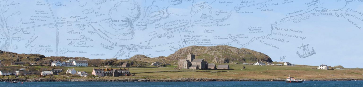
Main Street
Kilfinichen & Kilvickeon (KKV), Iona (IOX)
Classification: Other
Grid reference: NM2854924236
Certainty: 1
Altitude: 12m
Elements: SSE main + SSE street
Translation: 'Main street'
Description:
The earliest name for this feature is simply Street, as shown on the Douglas map of 1769 as a straight line running NNE most of the way from Teampall Rònain to the south transept of the Cathedral; before reaching the Cathedral, however, it deviates slightly to the east, approaching close to the west end of Caibeal Muire | St Mary’s Chapel, and then continuing towards the east end of the Cathedral. Five years later Thomas Pennant would describe it thus:
Advance from hence [i.e. from the nunnery] along a broad paved way, which is continued in a line from the nunnery to the cathedral: another branches from it to the Bay of Martyrs: and a third narrower than the others, points towards the hills (Pennant 1774, 283).
The course of the Main Street is also shown on the OS 6 inch 1st edn map, running in a straight line from Teampall Rònain to Crois MhicIllEathain | MacLean’s Cross, a section which coincides with the course of the modern road, and then breaking away from the modern road and continuing in a straight line marked ‘site of Main Street’ from MacLean’s Cross to the south transept of the Cathedral. On this map there is no eastward deviation of the street as shown on the 1769 map.
Main Street is not to be confused with Sràid nam Marbh | Street of the Dead (q.v.), which ran from Port nam Mairtir across what are now fields, to the west side of the nunnery and then probably continued more or less parallel to, and west of, Main Street until it reached Rèilig Odhrain, from where it continued to the west end of the Cathedral.
Maol
Kilfinichen & Kilvickeon (KKV)
Classification: Settlement
Grid reference: NM2802423910
Certainty: 1
Altitude: 26m
Elements: G maol
Translation: '(the) brow (of the hill)'
Maol an Aoinidh
Kilfinichen & Kilvickeon (KKV)
Classification: Relief
Grid reference: NM2565722173
Certainty: 3
Altitude: 52m
Elements: G maol + G an + G aoineadh
Translation: 'brow of the steep promontory'
Maol Buidhe
Kilfinichen & Kilvickeon (KKV)
Classification: Relief
Grid reference: NM2664223337
Certainty: 2
Altitude: 6m
Elements: G maol + G buidhe
Translation: 'yellow brow or promontory'
Maol Chalbha
Kilfinichen & Kilvickeon (KKV), Iona (IOX)
Classification: Relief
Grid reference: NM2825325814
Certainty: 1
Altitude: 7m
Elements: G maol + en Calbha
Translation: ‘brow or promontory of Calbha’
Description:
A raised stretch of land located near the coastline, north of Calva croft.
The specific element has been transferred from Eilean Chalbha or the croft of Calva. See Dùn Chalbha for further discussion.
Maol na Cìche
Kilfinichen & Kilvickeon (KKV)
Classification: Relief
Grid reference: NM2559622086
Certainty: 1
Altitude: 37m
Elements: G maol + G an + G cìoch
Translation: 'brow of the breast (-shaped hill)'
Maol nam Manach
Kilfinichen & Kilvickeon (KKV)
Classification: Relief
Grid reference: NM2764923109
Certainty: 1
Altitude: 38m
Elements: G maol + G an + G manach
Translation: 'brow of the monks'
Maol nan Druineach
Kilfinichen & Kilvickeon (KKV)
Classification: Relief
Grid reference:
Certainty: 4
Altitude: m
Elements: G maol + G an + G druineach
Translation: 'brow of the artisans or ?embroideresses'
Maol nan Uan
Kilfinichen & Kilvickeon (KKV)
Classification: Relief
Grid reference: NM2612022589
Certainty: 1
Altitude: 39m
Elements: G maol + G an + G uan
Translation: 'brow of the lambs'
Maol Phàidein
Kilfinichen & Kilvickeon (KKV)
Classification: Relief
Grid reference: NM2815325423
Certainty: 1
Altitude: 22m
Elements: G maol + pn Pàidean
Translation: 'Pat's brow'
Martyr Street
Kilfinichen & Kilvickeon (KKV), Iona (IOX)
Classification: Other
Grid reference: NM2855924037
Certainty: 1
Altitude: 4m
Elements: SSE martyr + SSE street
Translation: 'martyr street'
Description:
The course of the street as shown on the OS 6-inch 1st ed map runs WNW from the pier at St Ronan’s Bay, until it meets the old track coming north from Martyrs’ Bay or Port nam Mairtir (q.v.). There is no street at all shown here on the very detailed plan of Iona in 1769, which suggests that the street was constructed (and therefore its name invented) between 1769 and its first mention in 1798. Strangely, that 1798 reference to Martyr Street describes it as coming from the ‘bay of martyrs’, but that is not how it is shown on the OS 6-inch map. This suggests either that Garnett had misidentified the street’s course, confusing it with the street that runs directly north from Port nam Mairtir, or that the name Martyr Street in 1798 had in fact referred to the road from Port nam Mairtir to the nunnery, which was later called Sràid nam Marbh, and the name was only later transferred to the road from St Ronan’s Bay. In either case, we may assume that Martyr Street took its name from the use of the word mairtir in the name of nearby Port nam Mairtir (q.v. for discussion of the term martyr or mairtir).
Martyrs’ Bay
Kilfinichen & Kilvickeon (KKV), Iona (IOX)
Classification: Coastal, Ecclesiastical
Grid reference: NM2854823838
Certainty: 1
Altitude: 1m
Translation: 'martyrs' bay'
Murlugh
Kilfinichen & Kilvickeon (KKV)
Classification: Coastal
Grid reference: NM2754422363
Certainty: 1
Altitude: 9m
Murlugh Àird
Kilfinichen & Kilvickeon (KKV)
Classification: Coastal
Grid reference: NM2783422953
Certainty: 1
Altitude: 13m
Murlugh Ìseal
Kilfinichen & Kilvickeon (KKV)
Classification: Coastal
Grid reference: NM2784522930
Certainty: 1
Altitude: 11m
Músholm †
Kilfinichen & Kilvickeon (KKV), Iona (IOX)
Classification: Island
Grid reference: NM2573921616
Certainty: 1
Altitude: 4m
Elements: ON mús + ON hólmr