As the project reaches the final months of its first year, it seems appropriate to share more widely some thoughts on the maps and methods we are using – both to collect and analyse the place-names of Iona and to store this information in our database.
To give a bit of background, this project aims to research each of Iona’s place-names as thoroughly and in as much detail as possible. This covers many different types of place-names, ranging from names given to minor features only known by local residents, to more conspicuous features like Dùn I, discussed by Gilbert Márkus in a previous blog post.
At this stage you may wonder why studying these place-names is so important. The names studied as part of this project are testament to many centuries (sometimes even millennia) of history, culture and religion on Iona and elsewhere. They can tell us a lot about the spiritual heritage of the island and the role it has in the collective memory of different communities. They should therefore be viewed as artefacts in their own right. If you want to learn more about the project background and aims you can read about them here.
More specifically, we are investigating the meaning of each name, but we also want to explore many other things. Who coined the name? When? Can we learn more about why it was coined, particularly through local traditions associated with places or names? Of course, looking at maps can only provide some of this information, which is why local knowledge is so important. But let’s begin by looking some of our key maps for Iona.
The starting point for many Scottish place-name projects is to look at the Ordnance Survey maps. Using data from the GB1900 project, Brian Aitken, our systems developer, extracted place-names on and around Iona that appear on the 6-inch 2nd edition Ordnance Survey map. Originally consisting of roughly 100 place-names, this data provided a starting point for the database (also designed by Brian) which will form the basis of an online interactive web resource. You can view comparable examples of digital outputs from previous surveys of Scottish place-names here: Place-Names of the Galloway Glens and The Berwickshire Place-Name Resource.
Ordnance Survey name forms sometimes give a sense of official finality and correctness, but this is not always the case. You can read about an obvious example of this in our first blog post by Thomas Clancy in his discussion of Cobhain Cuildich (the modern OS Explorer map gives the spelling Tobhain Tuildich, a misreading of the Gothic letter C). Evidently, it is important to take other sources into consideration when deciding which spelling to use – blindly accepting Ordnance Survey forms as correct and finite can cause considerable problems.
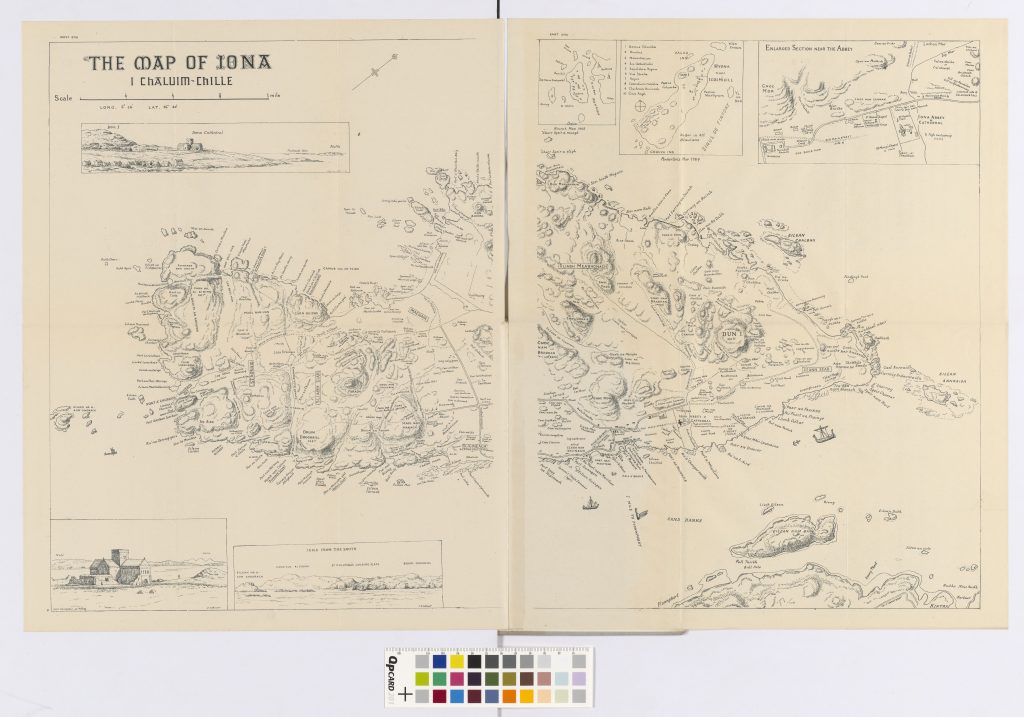
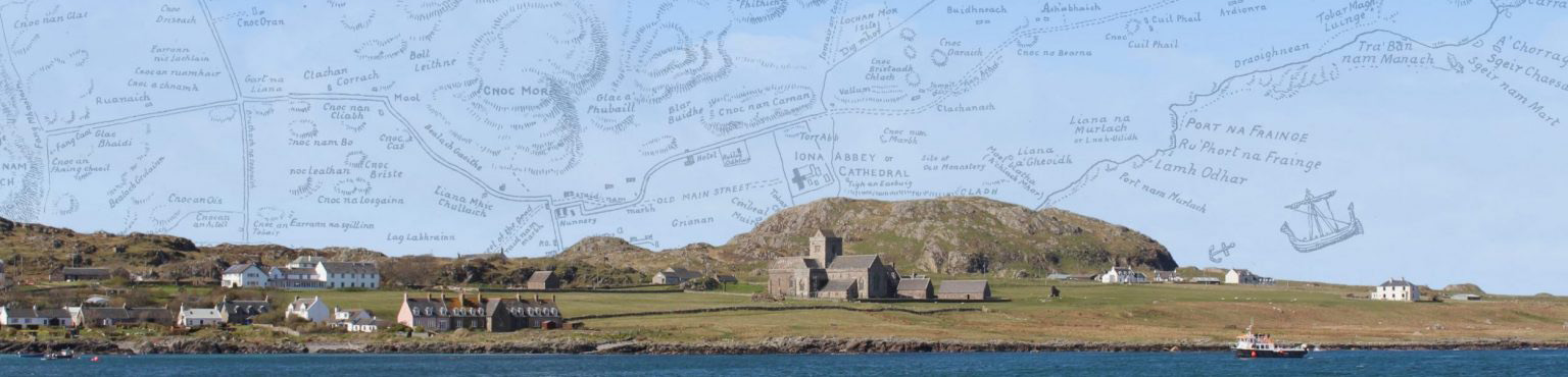
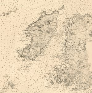
Additionally, many of the place-names we want to investigate as part of this project were never recorded by the Ordnance Survey, especially names of minor features like fields, rocks and skerries. Arguably, our most valuable resource to collect such minor place-names (also known as micro-toponyms) is the Ritchies’ 1928 map of Iona. The map is best used alongside D. Munro Fraser’s appendix of place-names which also includes his translations of the names into English. You can read more about the context of the map and the Ritchies in a previous blog post by Mairi MacArthur.
The sheer number of place-names included on the map is in itself testament to its value. As mentioned earlier, the extraction of GB1900 data provided just over 100 initial entries, but the total number of place-names recorded for Iona and surroundings by the Ordnance Survey in the 19th century is closer to 170. However, when including place-names recorded by the Ritchies and Fraser, our total number of place-names is closer to 500. A similar pattern can be found when looking at the use of G cnoc ‘hill, hillock’ – a very productive element in Iona place-names – which is found as the first element in 62 place-names recorded in Fraser’s appendix, but only 23 of these are recorded on 19th-century Ordnance Survey maps. This level of detail is quite unusual in the context of published maps for any part of Scotland, making it all the more valuable as a resource for place-name research. This also highlights its usefulness when studying minor place-names which are particularly prone to be missing from “official” maps.
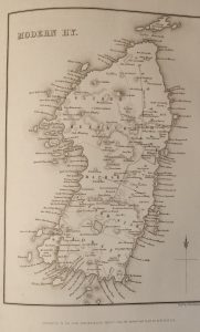
In addition to the Ritchie map two other maps of Iona should be mentioned here: William Reeves’ map of Iona included in his edition of Adomnán’s Life of Saint Columba (1857) and an Admiralty Chart of the Sound of Iona (1859) based on an 1857 survey.
Reeves provides the earliest systematic mapping of the place-names of Iona in considerable detail. His map can tell us a lot about the changes (and continuities) of the island’s place-names from the mid-19th century onwards when more maps start appearing. Although not as rich a source for place-names as Ritchie and Reeves, the 1859 Admiralty chart is remarkable due to its geographic accuracy and can therefore be used comparatively with Ritchie and Reeves.
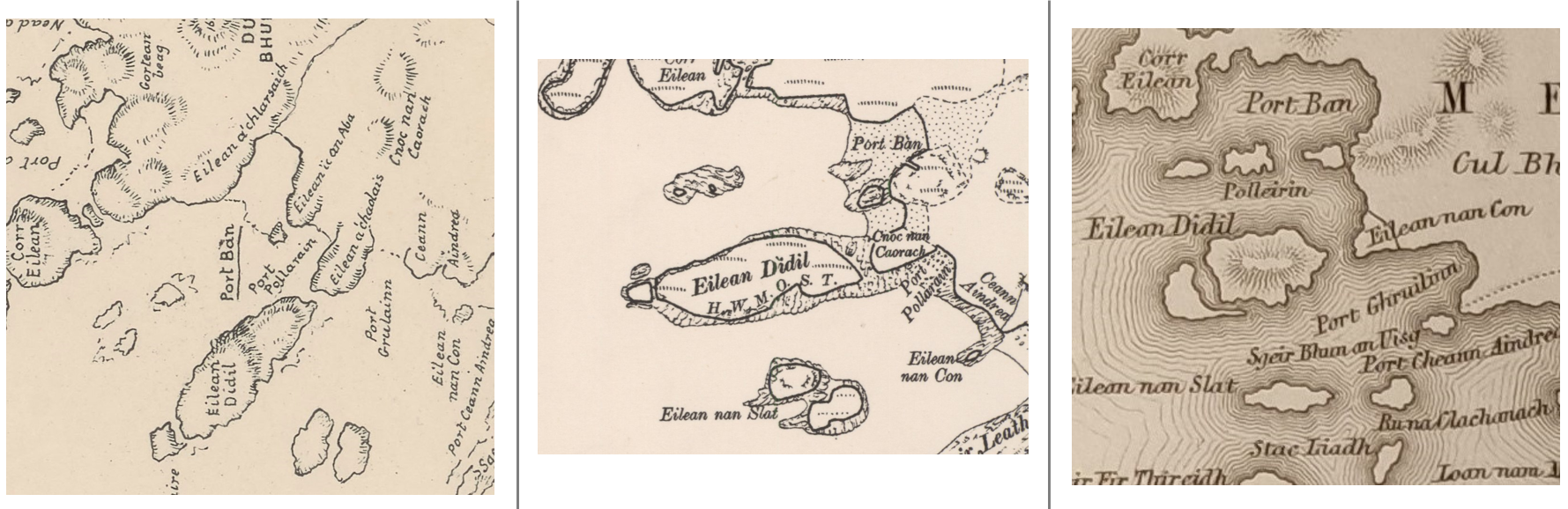
These three maps are used alongside the Ordnance Survey maps to systematically record variant spellings of place-names and any inconsistencies in locations given on these maps. We can look at a place-name like Eilean a’ Chaolais (grid reference: NM263242) to demonstrate this. On the Ritchie map it refers to a rock which connects with Eilean Dìdil on the western side of the island, but OS maps label the same feature Cnoc nan Caorach, a name which on the Ritchie map refers to a hillock further inland. On the other hand, on Reeves this feature is given as Eilean nan Con, a name found further south on the Ritchie map (see image for comparison). When such inconsistencies appear, we need to carefully consider any possible inaccuracies on the maps, but also take into account potential changes in how these names were (and are) understood by their users.
Also, despite having such rich resources there is still much work to be done. In many cases (but not always as illustrated above), figuring out the meaning and location of a place-name is fairly straightforward, but this does not tell us everything we want to know about that name, including some of the questions outlined above – who coined it? When? Why?
A case in point is Port an Duine Mhairbh (grid reference: NM264248), which can be translated as ‘Port of the dead man’. It is an intriguing name, but without further contextual evidence it arguably raises more questions than it answers. Who was the dead man? How did he die? When? In this instance we are fortunate to have some additional information: two oral recordings which can be accessed through Tobar an Dualchais mention this name. Peter MacInnes gave the following account in 1986: ‘all I heard was that it took its name from a body being discovered there at one time away in the long ago’ (ca. 3:55). Dugald MacArthur had no specific information regarding the name in 1966, but stated that it was a very old name (part 1, ca. 37:10). The name also appears on Reeves’ map as Port an Duine Marbh which is consistent with the relatively considerable age of this name observed in the oral recordings. We can also compare this name with other similar place-names and speculate about the likely, or unlikely, identity of the dead man; there is undoubtedly a wealth of references to dead men (and women) in Scottish place-names. For example, there is a Port Duine Mhairbh (grid reference: NM759142) on the island of Saoil/Seil for which the Ordnance Survey Name Books state that a man was shot there when attempting to desert a ship (check back for a future blog post on the Ordnance Survey Name Books). Perhaps our dead man was similarly ill-fated. It does seem likely that had he been a local resident, more would have been known of the circumstances of the incident. For example. The late Angus MacKay, of Highland Cottage, knew that his direct ancestor Roderick Cameron was drowned off the north end coast and is commemorated in the place-name Geodha Ruaraidh (grid reference: NM277258) (Mairi MacArthur pers. comm.). So, despite having a lot of contextual evidence, we are still left with many questions, some of which we may never be able to answer. However, this example illustrates why information from local residents of Iona is so important.
We are currently in the process of finalising our initial corpus of Iona place-names, a process which involves providing accurate locations (grid references), early spellings of individual names, going through antiquarian accounts and guidebooks, and much more. Despite delays in fieldwork activities (an inevitable result of the pandemic), visits to Iona to gather information about the landscape on the ground and to speak to the resident community, will form an important part of the next phase of research. Of course, we also need to remember that the Ritchie map does not constitute a final authority on the island’s place-names – how much has changed in the almost 100 years since it was originally published? To an extent, the only way to answer this question is to ask the people who now live on (or visit) Iona.
Do you know of any place-names that are not recorded on the Ritchie map? Are there any variations in spellings or locations? Do you know of stories connected with the place-names of Iona?